

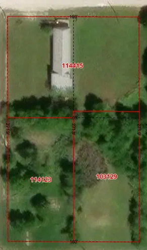
Figure 1. GIS parcel geometry is valuable for identifying and discussing property, but the displayed lines do not automatically establish a boundary on the ground.
A Familiar Question
A homeowner opens an online GIS map, turns on the property-line layer, and zooms in on the backyard. The colored line does not follow the fence. Sometimes it appears several feet away. Sometimes it crosses a driveway, garage, barn, or other visible improvement.
The homeowner’s first reaction is understandable: “Which one is wrong — the GIS line or the fence?”
The honest answer is that either one could be wrong. They could both be wrong. They could also represent different things that were never intended to match precisely.
A GIS parcel line is a digital representation. A fence is physical occupation. A legal boundary is determined from the relevant evidence.
What Is the GIS Line?
The line displayed by a county appraisal district, municipality, mapping website, or other GIS system is generally part of a digital parcel layer. That layer may have been assembled from recorded plats, deeds, appraisal maps, tax records, previous surveys, aerial imagery, older paper maps, CAD files, and information compiled from multiple sources over many years.
This information can be extremely useful. It allows organizations to connect parcels to tax accounts, support planning, display zoning, manage infrastructure, and help the public locate property. But the purpose of the parcel layer matters.
A parcel map created to associate an owner with a tax account may not have been designed to locate the legal boundary on the ground. In many cases, the lines are graphic representations fitted into a larger mapping system. That is very different from a boundary survey performed for a specific property.
Appearance Is Not Accuracy
A GIS line can look remarkably precise. It may be bright, sharp, and only a few pixels wide. When placed over aerial imagery, it can appear to define the property with certainty.
But the line’s appearance does not tell us the quality of its source, how it was positioned, whether monuments were located, whether adjoining deeds were reconciled, what coordinate system was used, or whether the imagery and parcel data have comparable positional accuracy.
A line can be drawn precisely in the wrong place.
What Does the Fence Represent?
A fence is evidence of occupation, but it is not automatically the property boundary. Fences may contain livestock, provide privacy, follow convenient terrain, avoid trees and creeks, connect improvements, approximate a believed line, or mark a boundary located by an earlier survey.
Some fences were carefully constructed along surveyed boundaries. Others were built by owners, contractors, ranch hands, or previous generations using the best information available at the time. A fence may have existed for decades without anyone knowing whether it follows the deed boundary.
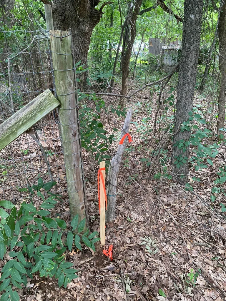
Figure 2. Multiple fence posts, different fence materials, occupation, and flagged survey evidence show why a boundary question cannot be answered by simply choosing the most visible fence.
This photograph illustrates the problem clearly. There is not one perfect, unquestionable line on the ground. There are different posts, different fence materials, changes in occupation, trees, age, and flagged evidence. The surveyor must determine what each feature represents and how it relates to the record and adjoining evidence.
The relevant questions include who built the fence, when and why it was built, whether a survey was used, whether it connects with found monuments, how the adjoining properties have been occupied, and whether owners historically recognized it as a boundary.
A fence is something to investigate, not something to automatically accept or reject.
Why the Lines May Not Match
- The parcel data may be generalized. It may have been created for appraisal, planning, or public-information purposes rather than precise boundary location.
- The aerial imagery may be shifted. Terrain, camera geometry, elevation models, processing, and control can affect the position of an orthophoto.
- The datasets may come from different sources. Parcel lines, roads, imagery, floodplains, utilities, and topography may have different dates, coordinate systems, and accuracy standards.
- The parcel geometry may have been transformed. Older maps may have been digitized, scaled, rotated, or adjusted to fit a modern GIS framework.
- The fence may not be on the boundary. It may have been built for convenience, moved, replaced, or constructed from approximate information.
- The record descriptions may conflict. Deeds and plats can contain gaps, overlaps, mathematical discrepancies, conflicting calls, or references to monuments that no longer exist.
The mismatch on the screen may reveal a genuine question, but it does not answer it.
So Which One Is Correct?
The GIS line should not automatically be accepted as the boundary. The fence should not automatically be accepted as the boundary. The deed dimensions should not be laid on the ground without considering the rest of the evidence.
Boundary surveying is not merely measuring between two convenient points or making the mathematical description fit an aerial photograph. A professional land surveyor evaluates deeds, plats, adjoining records, previous surveys, found monuments, occupation, roads, rights-of-way, easements, historical evidence, applicable law, and actual field measurements.
The surveyor then forms a professional opinion based upon the evidence and accepted surveying principles. That process may confirm the fence. It may support another location. It may also reveal a conflict that cannot responsibly be reduced to a simple colored line.
The Surveyed Conclusion
The survey map below connects the record with the evidence found on the ground. It identifies controlling and other found monuments, measured bearings and distances, adjoining record information, visible fence types, survey photographs, coordinate reference, survey notes, and the surveyor’s certification.
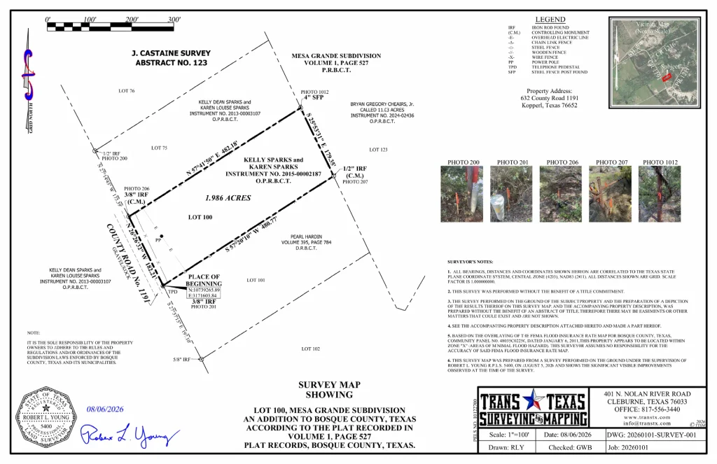
Figure 3. The completed boundary survey documents the professional conclusion after record information, field measurements, monuments, fences, occupation, and adjoining evidence were evaluated.
When Is the GIS Line Good Enough?
If the purpose is to find a property, understand its general shape, identify the neighborhood, plan a site visit, or discuss a project, the GIS parcel line may be entirely adequate. It is a valuable communication tool.
But decisions involving construction, setbacks, easements, rights-of-way, utilities, purchases, sales, subdivisions, or disagreements between neighbors require information appropriate to the consequences.
An online parcel viewer should not become the starting point for a confrontation. Before accusing someone of encroachment, moving a fence, removing an improvement, or beginning construction, obtain the appropriate records and professional survey information.
The GIS mismatch may be caused by the map. It may be caused by the imagery. It may be caused by the fence. It may reflect an actual boundary issue. Until the evidence is evaluated, the mismatch is a question — not a conclusion.
GIS and Surveying Become Stronger Together
GIS gives us the ability to see property information in context. Professional surveying provides the measurements, control, documentation, evidence analysis, and judgment required when the exact location matters.
GIS can show us that the colored line does not match the fence. A surveyor investigates why.
The line on the screen is information.
The fence on the ground is evidence.
The boundary is a professional conclusion based upon the relevant evidence.
When that conclusion matters to the decision —
GET IT SURVEYED.
Robert L. Young, RPLS 5400 • Trans Texas Surveying & Mapping
GIS — Get It Surveyed™ | A Robert L. Young Educational and Book Series
© 2026 Robert L. Young. All rights reserved. Reproduction or distribution requires written permission, except as permitted by law.