

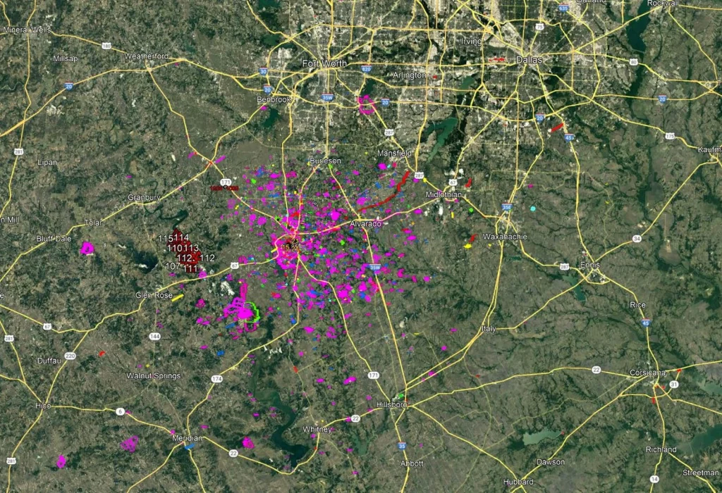
Figure 1. A regional Google Earth view can bring roads, communities, projects, and geospatial layers together on one understandable surface.
A picture can communicate location. A survey establishes position for decisions that require evidence, accuracy, and accountability.
A Question That Changed
“Where is my house?”
For most of history, answering that simple question was not particularly easy. You needed a street address, written directions, a paper road map, or someone who knew the area. Even then, you might know how to get to the house without knowing precisely where it was located on the earth.
Google Earth changed that.
Today, a person can type an address into a computer or phone and, within seconds, travel from a view of the entire planet to an image of a particular roof. We can see the street, the driveway, the neighboring properties, the creek behind the house, and sometimes even the fence around the backyard.
That ability changed our lives. It also changed what people expect from maps.
Google Earth is one of the greatest tools ever developed for communicating location. It helps us find places, understand relationships, explore unfamiliar areas, plan projects, and explain where something is situated. It gives ordinary people access to geographic information that once required specialized maps, equipment, and training.
But Google Earth also creates an important question:
Are we looking at a picture of where something is — or a measurement of where it is?
Those are not always the same thing.
It Communicates Location
If I send someone a Google Earth image with a mark on a building and say, “This is the house,” the image may communicate exactly what is needed. The person can understand the general location, recognize the property, and probably drive directly to it.
For that purpose, the information is extremely valuable.
It does not need to establish the property boundary to help someone find the house. It does not need to provide survey-grade coordinates to show a contractor the general project area. It does not need to identify the controlling elevation datum to help a family member recognize the neighborhood.
The map is accurate enough for the decision being made.
That phrase — accurate enough for the decision being made — is essential to understanding the relationship between GIS and professional surveying.
Not every map needs to be a survey. Not every location needs to be measured to the nearest hundredth of a foot. Many GIS applications work very well with approximate, generalized, or differently sourced information.
The problem begins when information created for one purpose is used for a different purpose requiring greater certainty.
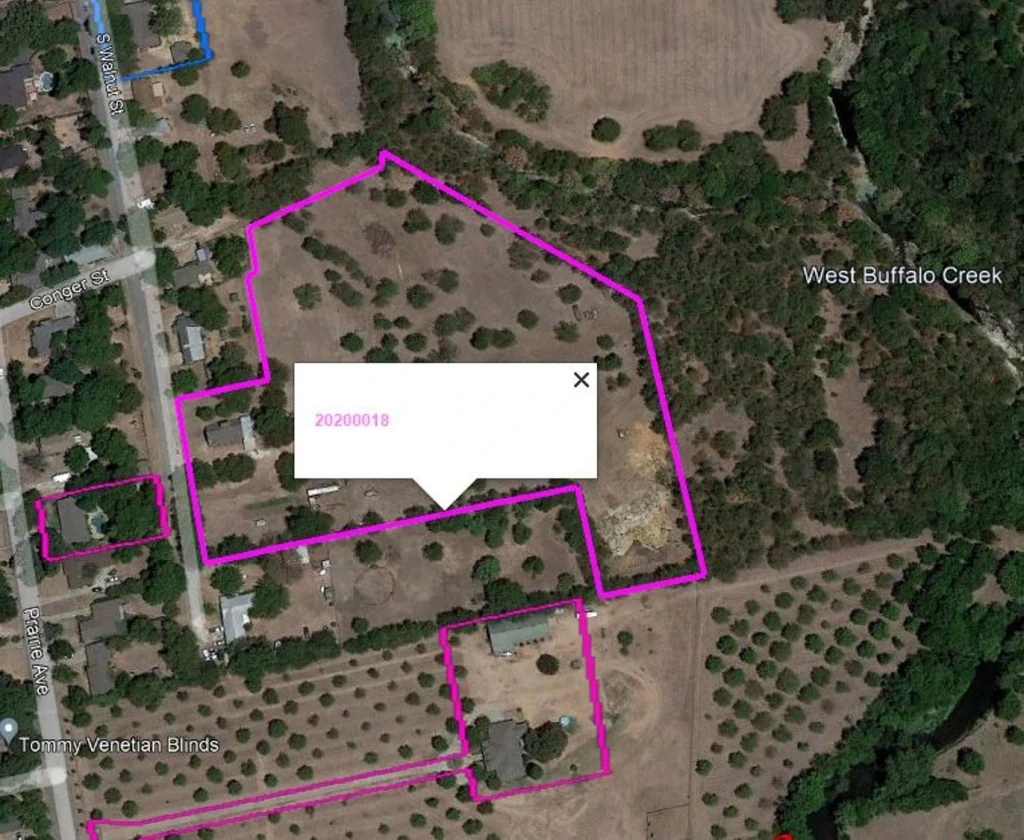
Figure 2. A parcel outline over aerial imagery is extremely useful for finding and discussing a property. Its clean appearance alone does not establish the legal boundary on the ground.
When the Picture Becomes Evidence
A homeowner may look at an aerial image with property lines displayed over it and conclude that a fence is on the neighbor’s property. A contractor may measure a distance on the screen and assume that it is sufficient for construction. A developer may compare a mapped floodplain with visible ground features and believe that the flood risk has been established.
At that point, the image is no longer being used merely to communicate location. It is being treated as evidence for a legal, financial, engineering, or construction decision.
That requires different questions:
- Where did the property lines come from?
- Were they established by a professional survey?
- How was the aerial imagery positioned?
- When was the imagery collected?
- What coordinate system and datum were used?
- What level of positional accuracy can be expected?
- Has the information been checked against reliable ground control?
- Is it accurate enough for this particular decision?
A clean-looking line on a computer screen can create a powerful impression of certainty. But the width, color, or sharpness of that line tells us nothing about the accuracy of the underlying data.
A line can be drawn precisely in the wrong place.
The Fence and the Property Line
One of the most common misunderstandings occurs when GIS property lines are displayed over aerial imagery.
Someone looks at the screen and says, “The property line runs through my garage,” or, “Google shows that my neighbor’s fence is three feet onto my property.”
Maybe it is. Maybe it is not.
The apparent difference may come from the property data, the imagery, the way the information was transformed or displayed, or a combination of those factors. The mapped parcel may have been created for appraisal or planning purposes rather than for locating a legal boundary on the ground. The imagery may also have positional limitations.
Most importantly, a property boundary is not established simply by placing a line over a photograph.
A professional land surveyor evaluates deeds, plats, monuments, occupation, adjoining ownership, historical evidence, applicable law, and actual field measurements. The surveyor’s responsibility is not merely to draw a line that fits the picture. It is to gather and evaluate the evidence necessary to form a professional opinion about the location of the boundary.
Google Earth can help us see the fence.
A survey helps us determine what relationship that fence has to the property boundary.
The Projection Is Not the Real World
Every flat map represents a curved earth through some form of mathematical transformation. This is what we mean when we talk about a map projection.
No flat map can preserve every characteristic of the earth perfectly. Depending upon the projection, there will be some distortion of distance, direction, area, shape, or scale. That does not make the map useless or invalid. It means the map must be understood in relation to its purpose.
Google Earth presents geographic information in a way that is remarkably effective for visualization. But what we see on the screen is still a digital representation assembled from imagery, terrain models, coordinates, processing methods, and information collected from multiple sources.
It is not the ground itself.
This distinction is easy to forget because the picture looks so real. The closer we zoom, the more certain we may feel. But enlargement does not create accuracy that was not present in the original information.
Zooming in makes the image larger. It does not make the underlying position more accurate.
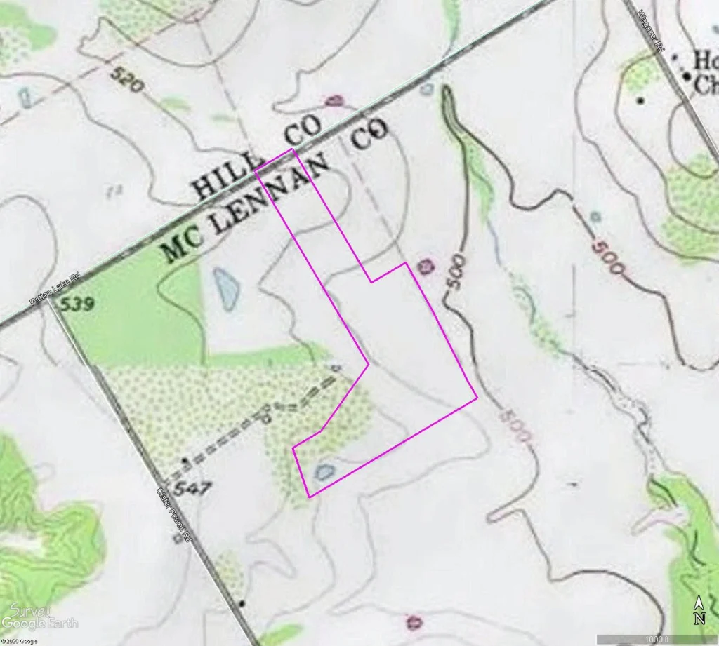
Figure 3. Historic topographic mapping, present-day road information, and a digital property outline can be combined to communicate context. Each layer has its own source, date, scale, and limitations.
Right for One Decision, Wrong for Another
Suppose I want to know whether a house is generally north or south of town. Google Earth can answer that.
If I want to see whether a property appears wooded, it may provide useful preliminary information.
If I want to plan a route to the site, examine surrounding development, or discuss a project with a client, it may be the best communication tool available.
But suppose I need to determine whether a building crosses a setback line; whether a fence encroaches across a property boundary; where to construct a foundation; the elevation required for floodplain compliance; the location of an easement; whether a utility is within a right-of-way; or whether two datasets align closely enough to support engineering design.
Those decisions may require professionally established control, field measurements, documented datums, appropriate accuracy standards, and independent checks.
The question is not whether Google Earth or GIS is good or bad. The question is whether the information is suitable for the decision we are asking it to support.
The Surveyed Answer
The survey map below does something the previous images were never intended to do. It documents the results of a survey performed on the ground. It identifies monuments and record information, shows measured bearings and distances, describes the coordinate reference, and carries the professional surveyor’s certification.
The earlier images help a reader find and understand the property. The survey map supports decisions that depend upon the location of its boundary.
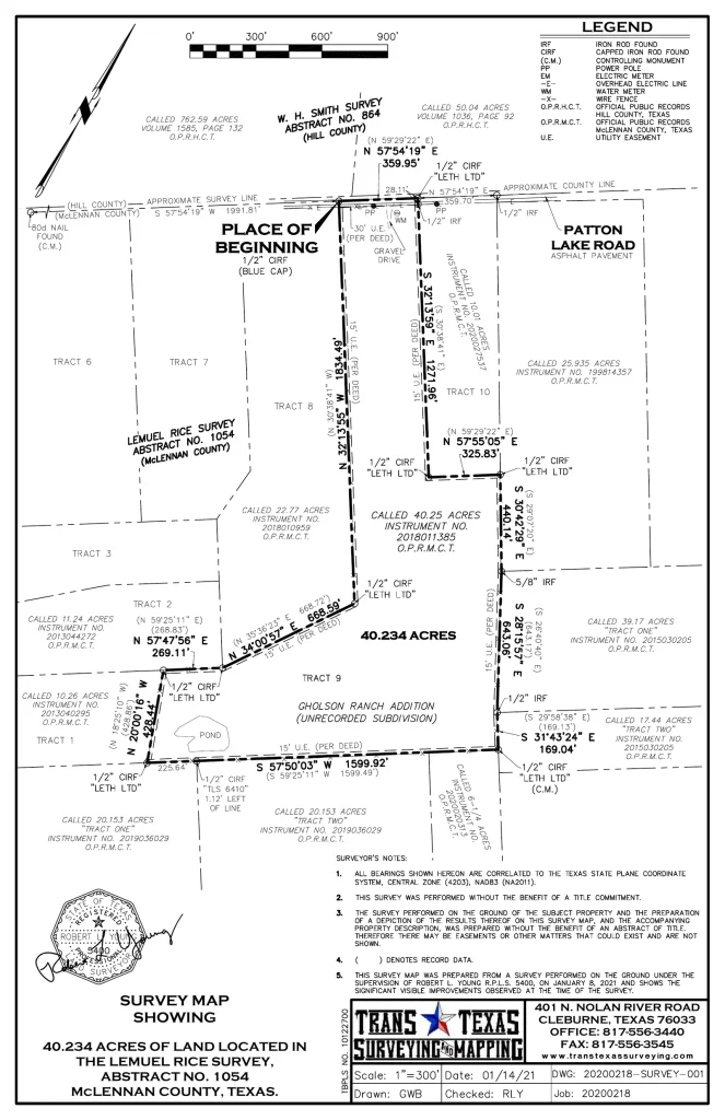
Figure 4. A professionally prepared survey map documents measured boundaries, monuments, adjoining record information, survey notes, coordinate reference, and the surveyor’s certification.
GIS and Surveying Need Each Other
GIS allows us to organize, visualize, compare, and communicate extraordinary amounts of information. Professional surveying provides reliable measurements, control, boundary determination, positional integrity, and documentation.
These professions should not be viewed as competitors.
GIS becomes more valuable when users understand the source and limitations of its data. Surveying becomes more valuable when accurate measurements are organized and communicated through modern geospatial systems.
The best results come when the two work together.
Google Earth may help us ask, “Where is my house?” Professional surveying helps us answer the more demanding questions:
- Where is the boundary?
- Where is the house in relation to that boundary?
- What is the elevation?
- What coordinate system and datum control the measurements?
- Can the location be independently verified?
- Is the information accurate enough for the decision we are about to make?
Google Earth changed our lives because it gave everyone a new way to see location. The next step is learning how to understand what we are seeing.
A picture can communicate location.
A map can organize location.
A GIS can analyze location.
A survey can establish position for decisions requiring reliable evidence.
But when the decision depends upon precisely where something is, how high it is, who owns it, or where it should be built —
GET IT SURVEYED.
Robert L. Young, RPLS 5400 • Trans Texas Surveying & Mapping
GIS — Get It Surveyed™ | A Robert L. Young Educational and Book Series
© 2026 Robert L. Young. All rights reserved. Reproduction or distribution requires written permission, except as permitted by law.