

You can have a million points.
You can have a hundred million points.
And the entire thing can still be in the wrong place.
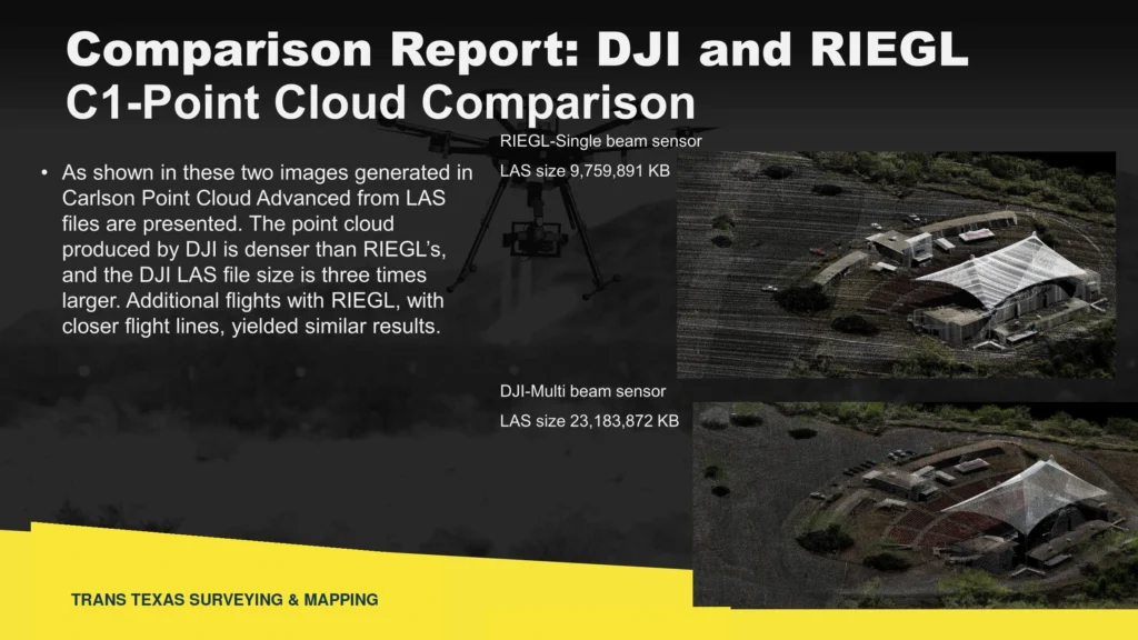
Figure 1. The same Glen Rose, Texas, amphitheater captured with a Phoenix LiDAR Systems RIEGL Mini 3 Lite and a DJI L2. The DJI dataset is visibly denser, but density and file size alone do not establish positional accuracy. Source: TTSM project comparison, August 2024.
CENTRAL IDEA A point cloud becomes dependable geospatial information only when we know what holds it in place, how it was checked, and whether it is accurate enough for the decision being made.
The Seduction of More Points
Modern LiDAR can collect an astonishing amount of information. A drone can fly a site and return millions of measurements. A terrestrial scanner can capture walls, seats, columns, utilities and structural details from many directions. The finished cloud may be so dense and realistic that the viewer feels as if standing inside it.
That visual power is useful. It helps us understand a place, communicate conditions and preserve a record of what existed on the day of collection. But density is not the same as accuracy. A beautifully detailed cloud can be internally consistent and still be shifted horizontally, vertically, rotated, scaled incorrectly or referenced to the wrong coordinate system or datum.
The problem is easy to miss because the data may look right. The amphitheater still looks like an amphitheater. The seats line up. The walls are crisp. The point count may be impressive. None of that proves where the model sits on the ground. TTSM’s August 2024 Glen Rose amphitheater survey evaluated two aerial LiDAR systems and terrestrial scanning on the same controlled project. This article uses that comparison to show why the check matters.
What Is Holding Up the Point Cloud?
Every geospatial dataset rests on something. The question is whether that support is known, documented and appropriate for the intended use.
For aerial LiDAR, the answer may include GNSS observations, the trajectory solution, calibration, processing parameters, ground-control points, checkpoints, the coordinate system, the vertical datum and the geoid model. For a terrestrial scan, it may include scan registration, surveyed targets, common control and independent checks. If those pieces are weak, or if nobody can explain them, the point cloud may contain a great many precise-looking points without providing a reliable position.
This is one of the most important distinctions in modern mapping: precision describes how closely measurements agree; accuracy describes how well they agree with the accepted position. A system can repeatedly produce a tight answer in the wrong place.
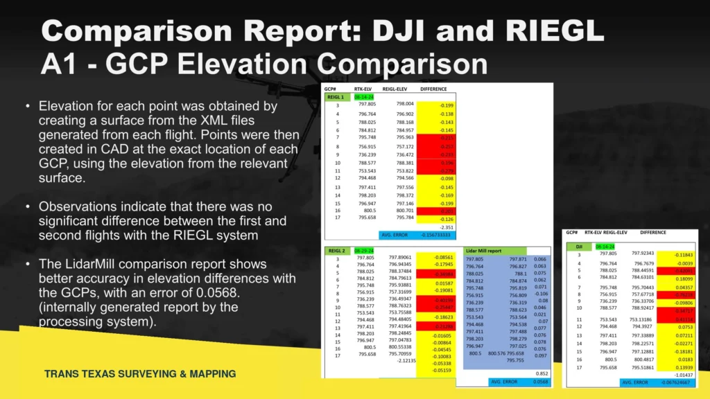
Figure 2. Surface elevations from the DJI L2 and RIEGL Mini 3 Lite collections were compared at established ground-control locations. The comparison turns an impressive image into testable survey evidence. Source: TTSM Glen Rose project comparison.
The Check Must Be Independent
A processing report is valuable, but the strongest check does not simply repeat the same assumptions that created the data. If the same workflow, base station, transformation or control is used to create and check the model, a common error can pass quietly through both steps.
Independent checkpoints give the dataset something outside itself to answer to. They help reveal whether the cloud agrees with measured positions on the ground. The check should be separated from the adjustment when practical, and the results should be reported honestly, not hidden behind a dramatic image or an enormous point count.
This does not mean every point cloud must meet survey-grade tolerances. A model created for visualization, public communication or early planning may be entirely useful with approximate positioning. The required support should rise with the consequence of the decision. Clearances, elevations, deformation, construction, utility conflicts, quantities and boundary relationships demand more than a picture that looks convincing.
There Is No Magic Instrument
At the Glen Rose amphitheater, the two aerial LiDAR systems and terrestrial scanning were not competitors. They were complementary tools. The aerial systems captured the larger site efficiently. The Leica RTC360 reached beneath roofs, around walls and into areas where the airborne sensors could not provide the same coverage or detail. Carlson BRx7 GNSS observations and conventional survey measurements connected the collections to project control and to the real property.
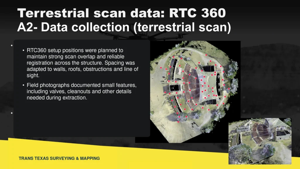
Figure 3. Leica RTC360 terrestrial scans supplemented the aerial collections at the amphitheater, including the seating and stage areas where roofs, walls and complex geometry limited airborne coverage. Source: TTSM Glen Rose project comparison.
The best instrument depends on the question, the site and the required result. GNSS is powerful in open sky. A total station can provide precise line-of-sight measurements and reliable checks. A drone covers ground quickly. A terrestrial scanner captures complex geometry. Records, monuments and occupation remain essential to boundary work. Professional judgment is what decides how those tools should be combined.
Technology amplifies the surveyor. It does not replace the surveyor.
From Point Cloud to Professional Deliverable
The raw point cloud is not the end of the work. It is one source of measured information. The professional deliverable brings the technology together with control, records, boundary evidence, easements, improvements, utilities, notes, coordinate references and the limitations that matter to the client.
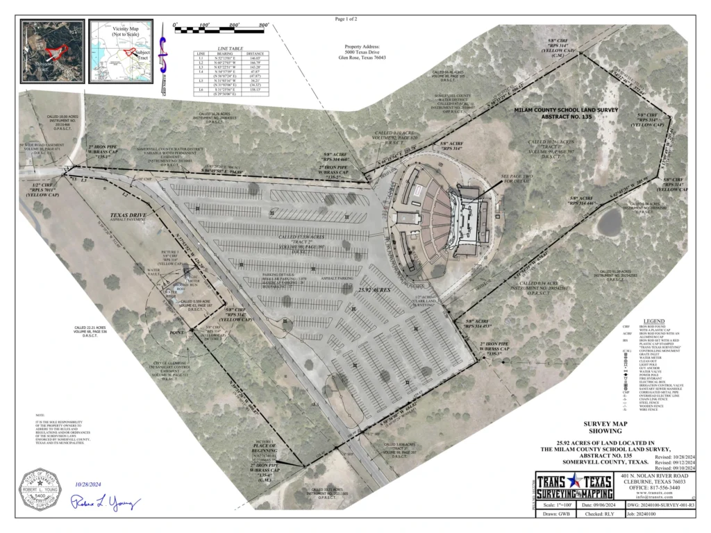
Figure 4. The August 2024 Glen Rose survey brings aerial imagery together with surveyed linework, monuments, dimensions, easements, notes and control in a documented professional deliverable. Source: Trans Texas Surveying & Mapping project survey.
The aerial image helps the reader understand the property quickly. The surveyed linework, monuments, dimensions, easements and notes explain the measured and documented relationships. Each view contributes something different. Together they are more useful than either one by itself.
This is the larger point behind Get It Surveyed. The objective is not to diminish LiDAR, GIS, drones or digital twins. These tools are extraordinary. The objective is to ask what the information is tied to, how it was verified and whether it is good enough for the decision someone is about to make.
When the Points Become Information
Once a point cloud is properly positioned, registered, checked and classified, it becomes far more than a picture. Classification separates ground, structures, conductors, poles, vegetation and other features into useful categories. Coordinates, elevations, diameters, spans and clearances can be measured directly in the registered dataset. The information can support GIS, engineering, asset management, construction planning and a digital twin that can be revisited long after the field crew leaves.
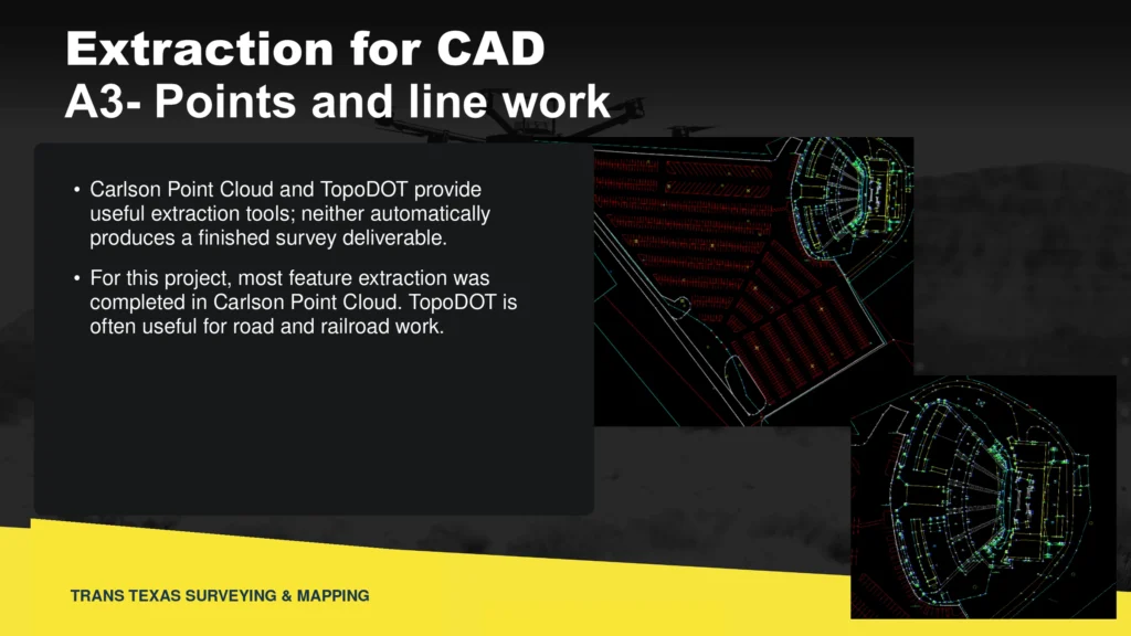
Figure 5. Glen Rose amphitheater point-cloud data extracted into CAD linework. Positioning, checking and professional interpretation are what turn collected points into useful survey information. Source: TTSM Glen Rose project comparison.
Ask the Questions the Image Cannot Answer
- Where did the coordinates and elevations come from?
- What coordinate system, datum and geoid model were used?
- How was the aerial or terrestrial data connected to control?
- Were independent checkpoints used, and what did they show?
- What processing, registration and classification steps were performed?
- What accuracy is required for the decision, and was that requirement actually tested?
GIS — GET IT SURVEYED More points can describe the world in greater detail. Control and verification tell us whether that description is in the right place.
A million points can be powerful. A hundred million points can be breathtaking. But before those points are trusted for an important decision, somebody still has to know whether they are right.
Robert L. Young, RPLS 5400 • Trans Texas Surveying & Mapping
GIS — Get It Surveyed™ | A Robert L. Young Educational and Book Series
© 2026 Robert L. Young. All rights reserved. Reproduction or distribution requires written permission, except as permitted by law.