
Why precision, GNSS, and GIS still depend on evidence and professional judgment
A modern GNSS rover can give us a coordinate in seconds. The receiver may show more decimal places than anyone would have written in a field book when I began surveying. We can occupy the point again, obtain nearly the same answer, stake back to it, and place it into CAD, GIS, a point cloud or a construction model.
It looks precise. It may be extraordinarily accurate. But there is still a question the receiver cannot answer: What have we actually found?
A coordinate tells us where a point is within a particular reference system. It does not, by itself, tell us whether that point is the property corner. Article 8, “Accuracy for What?”, asked what decision the data must support. This article takes the next step: not how well a position was measured, but what the measured point means.
CENTRAL IDEA: The instrument measures position. The surveyor determines meaning.
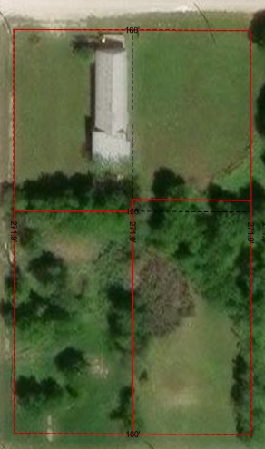
Figure 1. Original GIS parcel display from the TTSM image archive, with parcel identifiers obscured. This separate mapping example helps illustrate a search area; it does not establish property corners. Original image resolution limits print enlargement.
I Am Not Arguing Against GNSS
I started surveying in the 1970s, when our measurements, calculations, field notes and mistakes were more visible than they are today. A crew might spend much of a day doing work that a modern GNSS system can accomplish in minutes. I do not want to go backward.
Today we use GNSS, robotic total stations, LiDAR, laser scanning, drones and digital-twin technology. Modern positioning has made surveying faster, safer and capable of things I could hardly have imagined when I entered the profession. Better equipment, however, does not eliminate the reason the surveyor is there.
A Coordinate Answers One Question
A coordinate can answer, “Where is this point?” A boundary survey may require a harder answer: “Is this the corner that was created, marked, described, relied upon and carried forward through the history of this property?” Those are different questions.
A receiver does not know whether an iron pipe beside a fence is the original monument, a later replacement, a witness point or unrelated metal. It does not know whether a deed calls for the monument, whether an adjoining record recognizes it, why the fence is where it is, or why the records disagree. The receiver knows position. The surveyor must determine significance.
A Platted Lot Still Requires Retracement
On TTSM Job 20260101, we prepared a current boundary survey of a platted subdivision lot for conveyance. No title commitment was furnished; this was a boundary survey, not a title-company assignment. We began with the recorded subdivision plat and the lot’s legal description, then went to the ground to recover, measure and evaluate the physical evidence.
The field photograph illustrates the kinds of physical clues that may require investigation: fence remnants, posts, trees and a flagged stake. Those are observations, not conclusions about ownership. For Job 20260101, the recorded subdivision information and recovered monuments provided the evidence to be evaluated in retracing the lot.
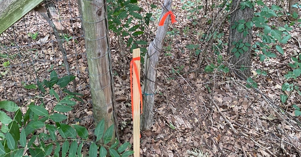
Figure 2. Original TTSM field photograph showing fence remnants, posts, trees and an orange-flagged stake. What these visible features mean for a boundary requires records, measurements and professional evaluation.
On our completed survey drawing, the notation “C.M.” means “controlling monument.” The drawing identifies found 3/8-inch and 1/2-inch iron rods as controlling monuments used in retracing the platted lot. We located and measured that evidence, analyzed it in relation to the recorded plat, and prepared a current boundary survey for the client’s conveyance. That is a professional retracement—not simply a coordinate plotted from a GIS layer.
The controlling monuments identified on the actual survey, considered with the recorded subdivision information and field measurements, supplied the basis for the retraced boundary. The photographs alone cannot tell us what controlled. Because no title commitment was furnished, this survey should not be mistaken for a title-company examination of potential title matters.
Precision Is Not Evidence
As Article 8 explained, a tight cluster of observations can still be in the wrong place. Here the problem is not only positional accuracy; it is the identity of the corner. Suppose a stake was set years ago from an assumed coordinate. A later crew occupies it with modern GNSS and obtains essentially the same position. The observation may be excellent. The stake may still fail to represent the controlling boundary evidence.
“The coordinate checks” is therefore an incomplete statement. Checks against what? The same file? The same localization? The same assumed control? A result can be internally consistent without answering the boundary question.
When the Monument Does Not Fit the Math
Older surveys rarely fit modern expectations perfectly. Measurements were made with different instruments, under different conditions, from control that may no longer exist. Deeds may contain rounding, transcription errors or calls that conflict. Fences and other physical evidence may have their own histories.
Texas boundary-construction rule 22 TAC §138.85 addresses senior and junior rights, the footsteps of the original surveyor, appropriate record research, physical monumentation, and the priority of calls. Section 138.91(a) and (e) addresses documenting the relationship of record monuments to the surveyed boundary and identifying monuments found or placed. Those duties call for research and judgment. Software can help measure and compare evidence; it cannot decide the boundary for us.
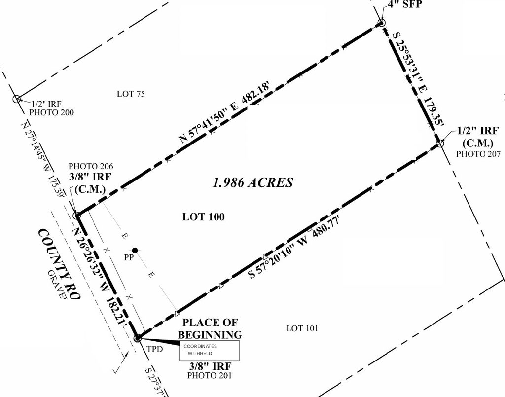
Figure 3. Actual excerpt from the TTSM platted-lot boundary survey—not a recreated diagram. Found 3/8-inch and 1/2-inch iron rods are identified as C.M. (controlling monument). Original boundary geometry, bearings, distances and monument annotations are retained; owner identifiers, the road number and precise coordinate values are withheld for privacy. Educational excerpt only, not the signed survey.
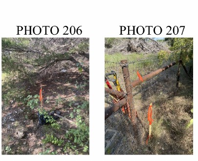
Figure 4. Original PHOTO 206 and PHOTO 207 details from the same TTSM survey sheet, corresponding to the found iron rods labeled C.M. on the boundary exhibit.
Two Coordinates Can Describe the Same Monument
Even the same physical monument can have different coordinate values under different reference frames, epochs, projections, units, localizations or transformations. A coordinate without that information is incomplete. A copied number may help with reconnaissance, but its basis must be verified before it is used for more demanding work.
This does not make coordinates unreliable. The monument is a physical object; the coordinate is a numerical description of its position within a defined system.
“Stake the Coordinate” Is Not Always the Right Instruction
In construction work, staking a design coordinate may be exactly the assignment. The engineer has defined a proposed point, and the surveyor places it using project control and specifications. In boundary work, a coordinate is more often a search tool or one piece of evidence. The task is retracement and evaluation—not simply reproducing a number supplied by someone else.
That distinction should be settled before the crew leaves the office. Is the point proposed construction, a control point, a GIS location, a record coordinate or an asserted property corner? Article 8 asked us to define the decision first. This is a practical example of why.
GIS Needs the Same Distinction
GIS is valuable because it organizes and communicates geographic information at scale. Parcel layers, imagery, utilities, flood information and asset records help us understand relationships and plan work. Trouble begins when a displayed line is treated as having the same authority as a boundary established by a professional survey.
A parcel layer may be excellent for planning a field visit and unsuitable for building a fence or acquiring an easement. That is not a failure of GIS. It is a failure to ask what the data was intended to support.
The Surveyor’s Signature Means More Than a Measurement
The signature and seal represent professional responsibility for the work—not a claim that a receiver displayed a convincing coordinate. Research, monument recovery, measurement, evaluation, appropriate checking and documentation are what give the result meaning.
Better technology should produce better-informed surveyors, not less thoughtful ones. GNSS can help us search efficiently, measure defensibly and document clearly. It should not tempt us to substitute decimal places for evidence.
CENTRAL IDEA: The coordinate is one measurement within the larger work of finding, understanding, documenting and defending the corner.
GET THE RECORDS. FIND THE EVIDENCE. MEASURE IT. CHECK IT. GET IT SURVEYED.
Technical reference: Texas Board of Professional Engineers and Land Surveyors, 22 TAC §§138.85 and 138.91 (boundary construction and survey drawing/report requirements), pels.texas.gov/downloads/lawrules.pdf
Robert L. Young, RPLS 5400 | Trans Texas Surveying & Mapping | www.transtx.com
GIS — Get It Surveyed™ | A Robert L. Young Educational and Book Series
© 2026 Robert L. Young. All rights reserved. Reproduction or distribution requires written permission, except as permitted by law.