

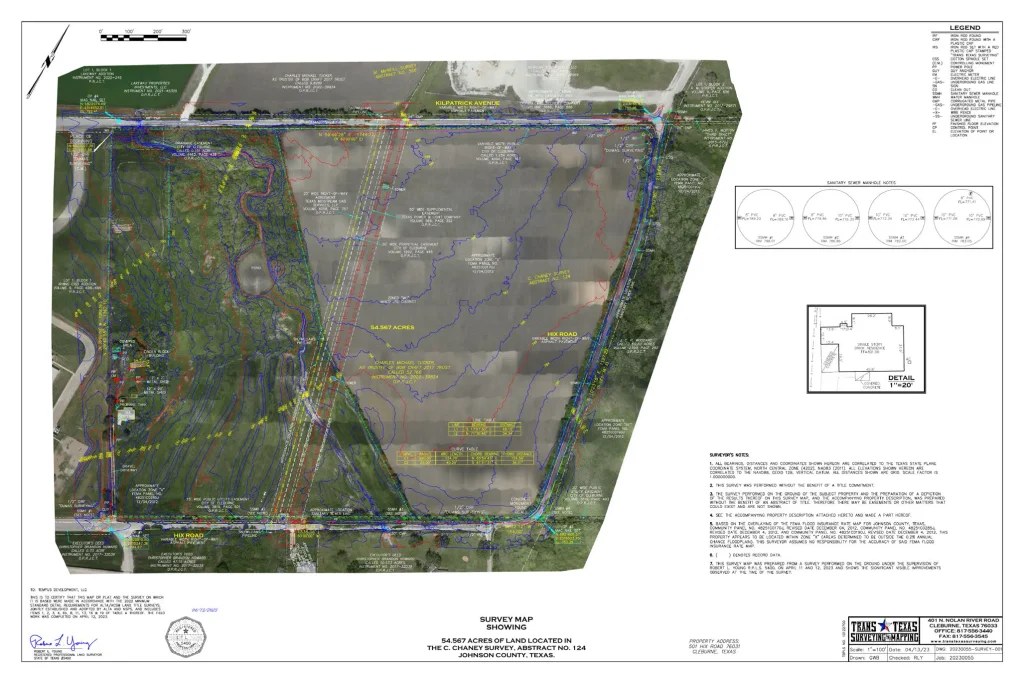
An aerial-based survey map provides immediate context: terrain, roads, drainage, improvements, and the relationship of the property to its surroundings.
A map does not have to be wrong to create the wrong expectation. It may correctly show a parcel, utility, floodplain, road, or structure, and still lack the positional accuracy needed for the decision someone is about to make.
CENTRAL IDEA Accuracy is not only a property of the map. It is a relationship between the map and the decision being made.
Right for What Purpose?
GIS has changed how quickly we can understand land. A county parcel map can help identify ownership. An aerial photograph can show visible improvements. A FEMA map can flag potential flood risk. A utility map can help organize a project corridor. Each may be entirely appropriate for its intended purpose.
The problem begins when a map prepared for general information is used as though it were a field measurement. The issue is not that the GIS is useless. The issue is that the user has quietly changed the question.
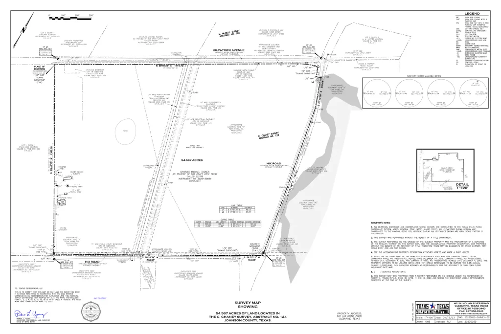
The same 54.567-acre project without the aerial background. The measured boundary, easements, rights-of-way, utilities, monuments, dimensions, and survey notes become the primary evidence.
The Same Property, Two Useful Views
The aerial version communicates the site quickly. It is excellent for orientation, planning, and explaining the project to someone who may not regularly read a survey drawing. The linework version removes much of the visual context so that the measured relationships are easier to evaluate.
Neither view automatically makes the other “wrong.” They serve different communication needs. But when the question becomes where to construct, excavate, acquire, insure, or resolve a boundary, the required level of support changes.
Correct Attribute, Uncertain Position
GIS commonly combines descriptive information with geometry. The descriptive information may be correct: the owner’s name, appraisal account, utility type, zoning category, flood zone, or recorded document reference. Yet the line displayed on the screen may have been compiled from a different source, scale, date, datum, or level of control.
This creates an important distinction: a record can be correct about what something is without locating precisely where it is on the ground.
A Utility Map May Be Right
A utility line shown along the correct roadway may be perfectly suitable for planning and coordination. It may not be accurate enough to place a drill path or begin excavation. For that decision, field designation, potholing, and survey control may be required.
A Flood Map May Be Right
A FEMA map may correctly identify an area of potential flood hazard. It may not establish the elevation of a specific building pad or determine whether the mapped limit agrees with current ground conditions. That requires site-specific vertical control, topographic measurements, and appropriate engineering or floodplain analysis.
A Parcel Map May Be Right
A parcel layer may correctly identify the tract and taxpayer. It may not be accurate enough to locate a fence, build a wall, set a corner, or decide ownership of a narrow strip. Those questions depend on record evidence, monuments, occupation, measurements, and professional boundary analysis.
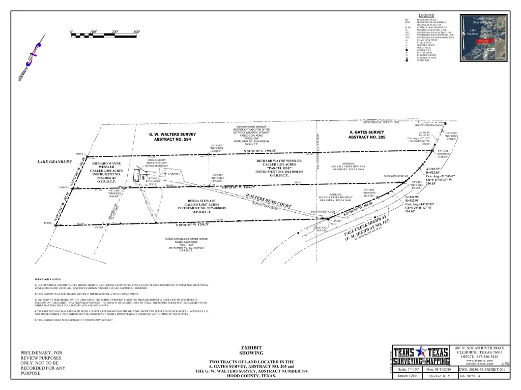
A survey exhibit adds measured bearings, distances, monument calls, improvements, road geometry, adjoining ownership, and professional notes, the information needed to evaluate a more consequential question.
Accuracy Must Match Consequence
The more permanent, costly, or legally consequential the decision, the stronger the positional support should be. A map used to find a property for a first visit does not require the same confidence as a map used to pour concrete, acquire right-of-way, excavate near a utility, or settle a boundary disagreement.
| Decision | Information usually needed |
|---|---|
| Orientation or early planning | GIS parcel layers, aerial imagery, public maps, and record research may be sufficient. |
| Preliminary design | Current base mapping, verified control, selected field checks, and documented source limitations. |
| Construction or excavation | Survey control, measured surface features, verified utilities, and clearly stated tolerances. |
| Boundary or ownership decision | Record research, recovered evidence, occupation, field measurement, analysis, and a professional survey. |
| Floodplain or elevation decision | Site-specific vertical control, current topography, datum information, and appropriate floodplain analysis. |
Ask Better Questions of Every Map
- What was it made for? A tax map, navigation map, construction survey, and boundary survey answer different questions.
- Where did the geometry come from? Record plats, digitized imagery, GNSS observations, LiDAR, and field survey measurements carry different capabilities and limitations.
- How current is it? The world changes. Roads move, utilities are added, drainage is altered, and fences are rebuilt.
- What control and datum support it? Coordinates and elevations are meaningful only when their reference framework is known and suitable.
- What is the cost of being wrong? The required accuracy should rise with the consequence of the decision.
GIS — GET IT SURVEYED Use GIS to understand the question. Use surveying when the answer must be measured, defensible, and accurate enough for the consequence.
The Map Is Not the Decision
The best use of GIS is not to ask it to become something it was never intended to be. GIS is extraordinarily valuable for organizing information, revealing patterns, communicating location, and guiding investigation. Surveying adds measurement, control, evidence, documentation, and professional responsibility when the decision requires them.
The map may be right. The wiser question is whether it is accurate enough for what you are about to do.
Robert L. Young, RPLS 5400 • Trans Texas Surveying & Mapping
GIS — Get It Surveyed™ | A Robert L. Young Educational and Book Series
© 2026 Robert L. Young. All rights reserved. Reproduction or distribution requires written permission, except as permitted by law.